Disaster Alerts: The Power of Mobile Early Warning Systems
Disasters, whether natural or man-made, can strike unexpectedly, causing immense loss of life, property, and economic stability. Fortunately, advancements in technology have revolutionized disaster management, particularly through mobile alerts and satellite-based early warning systems. These tools provide crucial time for evacuation and preparedness, ultimately saving countless lives.
Natural disasters such as tsunamis, cyclones, earthquakes, and wildfires pose significant threats to human life and property. In recent years, advancements in satellite technology have played a crucial role in mitigating these dangers by enabling early warning systems. These systems provide timely alerts through mobile devices, offering crucial evacuation time that can save countless lives. This article explores how satellite technology is revolutionizing disaster management by integrating with mobile networks to deliver real-time alerts and warnings.
In this article, we will explore the role of mobile alerts, early warning systems, and satellite technology in mitigating the devastating impact of natural disasters like tsunamis and cyclones.
The Importance of Early Warning Systems
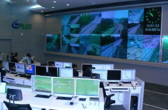
Early warning systems are essential in reducing the impact of natural disasters. When disasters strike without warning, the loss of life and damage to infrastructure can be catastrophic. However, when people receive timely alerts, they can take necessary precautions, evacuate, and avoid hazardous areas. The effectiveness of these systems depends on their ability to rapidly collect, process, and disseminate critical information.
Satellite technology plays a key role in this process, providing real-time monitoring, data collection, and communication capabilities that enhance disaster preparedness and response. By integrating with mobile networks, satellite-based early warning systems ensure that even people in remote or disaster-prone areas receive alerts on time.
Early warning systems (EWS) work by detecting, analyzing, and disseminating information regarding imminent threats, allowing authorities and individuals to take appropriate action before disaster strikes. There are four key components of an effective EWS:
- Risk Identification and Monitoring – Using satellite data, seismic sensors, and meteorological observations to detect potential disasters.
- Forecasting and Warning Generation – Processing real-time data to generate accurate predictions.
- Dissemination and Communication – Broadcasting alerts through mobile networks, sirens, social media, and radio.
- Response Capability – Ensuring communities are educated and equipped to act on warnings.
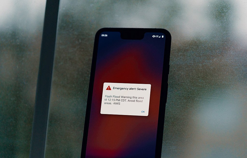
Among various dissemination methods, mobile alerts have become the most effective means of reaching people instantly, especially in disaster-prone regions.
Mobile Alerts for Natural Disasters
How Mobile Alert Systems Work
Mobile alerts operate through government agencies, meteorological departments, and disaster response organizations. These alerts use different technologies, such as:
- Cell Broadcast Messages (CBM): These are text messages sent to all mobile devices in a specific geographic area, ensuring that everyone in the vicinity receives the warning, regardless of whether they are locals or tourists.
- Short Message Service (SMS): Targeted text messages sent to subscribers in affected areas.
- Push Notifications: Weather and disaster apps send alerts to smartphones with real-time updates.
- Emergency Alert System (EAS): Used by authorities to send critical messages through mobile carriers.
Advantages of Mobile Alerts
- Instant Communication: Alerts are transmitted within seconds, providing crucial lead time for evacuation.
- Wide Coverage: Almost everyone owns a mobile phone, making it the most accessible medium for disaster warnings.
- Localized Information: Messages can be tailored to specific areas, reducing panic and confusion.
- Multi-language Support: Authorities can send messages in different languages to ensure clarity for diverse populations.
- Two-Way Communication: Some systems allow users to send distress signals and request help.
How Satellite Technology Works in Disaster Alerts
Satellite technology enables mobile devices to receive disaster alerts in multiple ways. Below are the key components and processes involved:
- Monitoring and Data Collection: Satellites continuously monitor weather patterns, ocean activity, seismic movements, and other environmental indicators. For example, geostationary satellites such as GOES (Geostationary Operational Environmental Satellites) provide real-time images of storm formations, while low-Earth orbit satellites like Sentinel-1 detect changes in sea levels and tectonic activity.
- Data Processing and Analysis: Once satellite data is collected, it is analyzed using AI and machine learning algorithms to detect anomalies and predict potential disasters. Organizations like the National Oceanic and Atmospheric Administration (NOAA) and the European Space Agency (ESA) utilize this data to generate alerts for impending threats such as tsunamis, hurricanes, and floods.
- Transmission of Alerts to Mobile Devices: Once a threat is identified, alerts are transmitted through satellite networks to mobile carriers and emergency services. These alerts are then relayed to mobile devices using SMS, push notifications, and cell broadcast systems.
- Direct-to-Mobile Satellite Communication: Emerging satellite technologies, such as those developed by SpaceX’s Starlink and AST SpaceMobile, are enabling direct-to-mobile communication. This ensures that alerts reach individuals even when cellular networks are down, making it a game-changer for disaster-prone regions.
Challenges of Mobile Alert Systems
While mobile alerts are highly effective, they are not without challenges:
- Network Congestion: High traffic can delay message delivery during emergencies.
- Device Compatibility: Older phone models may not support modern alert technologies.
- False Alarms: Repeated false warnings can cause complacency among residents.
- Limited Internet Access: Rural and remote areas may lack the infrastructure to receive alerts effectively.
Despite these challenges, continued improvements in mobile alert technologies are enhancing their reliability and efficiency.
Tsunami Early Warning Systems
Tsunamis are among the deadliest natural disasters, often triggered by undersea earthquakes, volcanic eruptions, or landslides. Early detection is crucial to saving lives.
How Tsunami Warning Systems Work
Tsunami early warning systems rely on:
- Seismometers: Detect undersea earthquakes that could generate tsunamis.
- Deep-ocean Assessment and Reporting of Tsunamis (DART) Buoys: Measure sea level changes and transmit real-time data.
- Satellite Monitoring: Tracks sea surface anomalies and wave movements.
- Coastal Tide Gauges: Measure abnormal rises in sea level near shorelines.
Once a tsunami threat is detected, warnings are issued through mobile alerts, sirens, and emergency broadcasts.
Case Studies: Life-Saving Tsunami Alerts
- Indian Ocean Tsunami (2004): The disaster, which claimed over 230,000 lives, underscored the need for better warning systems. Today, the Indian Ocean Tsunami Warning System (IOTWS) provides real-time alerts to at-risk regions.
- Japan’s Tsunami (2011): Japan’s advanced earthquake and tsunami warning system provided crucial minutes for evacuation, reducing casualties significantly.
Cyclone Early Warning Systems
Cyclones, also known as hurricanes or typhoons, are violent storms with destructive winds and heavy rainfall. Effective early warning systems are essential to minimize loss of life and property damage.
How Cyclone Early Warning Systems Work
- Satellite Imaging: Observes storm formations and tracks movement.
- Doppler Radar: Measures wind speeds and precipitation.
- Weather Buoys and Ships: Collect data on atmospheric pressure and sea temperatures.
- Computer Models: Forecast storm paths and potential landfall zones.
Mobile Alerts for Cyclones
Authorities issue cyclone warnings in stages:
- Pre-Cyclone Alerts: Advisories about potential storm formation.
- Cyclone Warning: Alerts about imminent impact and suggested evacuation plans.
- Cyclone Landfall Updates: Real-time updates on wind speeds and affected regions.
Case Studies: Effective Cyclone Warnings
- Cyclone Phailin (India, 2013): Early mobile alerts and mass evacuations reduced fatalities to 45, compared to over 10,000 in a similar storm in 1999.
- Cyclone Idai (Mozambique, 2019): Delays in issuing alerts resulted in over 1,300 deaths, highlighting the need for improved warning systems.
Real-Life Applications of Satellite-Based Disaster Alerts
Several countries and organizations have successfully implemented satellite-based early warning systems. Here are some notable examples:
- Tsunami Warning System in the Pacific Ocean: The Pacific Tsunami Warning Center (PTWC) uses satellite data to monitor underwater seismic activities. When an earthquake is detected, PTWC quickly analyzes the data and sends alerts to coastal regions via mobile networks, radio, and sirens.
- Cyclone Warning in India and Bangladesh: The Indian Space Research Organisation (ISRO) and the Bangladesh Meteorological Department use satellite imagery to track cyclones. Alerts are sent through mobile networks, giving residents time to evacuate before landfall.
- Emergency Alert System in the United States: The Integrated Public Alert and Warning System (IPAWS) uses satellite communication to send wireless emergency alerts (WEA) directly to mobile phones. These alerts inform people about hurricanes, wildfires, and other disasters.
- Early Warning System for Wildfires in Australia: The Australian Bureau of Meteorology leverages satellite data to predict and track wildfires. The country’s emergency agencies use mobile alerts to inform residents of evacuation plans and fire containment measures.
Satellite-Based Early Warning Systems
Satellites play a pivotal role in disaster management by providing real-time data on various natural hazards.
Types of Disaster Monitoring Satellites
- Geostationary Satellites (GEO): Monitor weather patterns and storm developments.
- Polar-Orbiting Satellites (LEO): Provide high-resolution images of affected areas.
- Synthetic Aperture Radar (SAR): Captures data on flooding, landslides, and earthquakes.
Key Satellite Programs
- GOES (Geostationary Operational Environmental Satellites): Used by the U.S. National Oceanic and Atmospheric Administration (NOAA) for hurricane tracking.
- INSAT (Indian National Satellite System): Provides early warnings for cyclones and floods in India.
- Sentinel (European Space Agency): Monitors climate change and natural disasters worldwide.
Benefits of Satellite-Based Warnings
- Global Coverage: Monitors disasters across vast regions.
- Real-Time Data: Provides instant updates on developing hazards.
- Enhanced Forecast Accuracy: Combines multiple data sources for reliable predictions.
- Remote Area Monitoring: Helps reach isolated populations.
Future of Disaster Alerts and Warning Systems
The future of disaster alert systems is focused on improving accuracy, speed, and accessibility. Innovations include:
- Artificial Intelligence (AI): AI-powered analytics can enhance prediction models.
- Internet of Things (IoT): Smart sensors and wearable devices will provide real-time data.
- Drones and UAVs: Used for post-disaster assessments and communication in remote areas.
- 5G Technology: Faster data transmission for more efficient mobile alerts.
Challenges and Future Developments
Despite its benefits, satellite-based disaster alert systems face certain challenges:
- High Costs: Deploying and maintaining satellite infrastructure requires significant investment. Governments and private organizations must collaborate to make these systems more affordable and accessible.
- Connectivity Issues in Dense Areas: While satellite communication is effective in open areas, urban environments with tall buildings may experience signal interference.
- Public Awareness and Compliance: People must be educated on how to respond to alerts. Governments should conduct regular awareness campaigns to ensure effective compliance.
Looking ahead, advancements in satellite miniaturization, AI integration, and global satellite networks will further enhance disaster preparedness. Projects like Amazon’s Project Kuiper and OneWeb aim to expand satellite coverage, making disaster alerts more accessible worldwide.
Mobile alerts and satellite-based early warning systems are vital tools in disaster preparedness and response. Whether warning of tsunamis, cyclones, or other natural hazards, these technologies provide critical lead time for evacuation, ultimately saving lives. As advancements continue, integrating AI, IoT, and next-generation communication systems will further enhance the effectiveness of disaster alerts, ensuring that communities worldwide remain resilient in the face of natural calamities. image/wikimedia