How Satellite Technology Powers Weather Apps for Smartphones
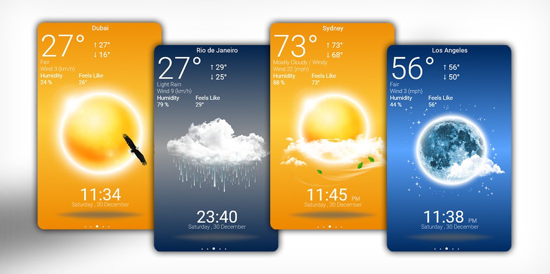
Weather apps have become indispensable tools for millions of smartphone users worldwide. They help people plan their daily activities, travel, and even critical events by providing accurate and timely weather forecasts. But have you ever wondered how these apps get their data? The answer lies in the sophisticated network of weather satellites orbiting Earth. These satellites collect, analyze, and transmit meteorological data, which is then processed and displayed in weather applications. In this article, we will explore how satellite technology powers weather apps, the types of satellites used, how data is collected and processed, and how this information helps individuals plan their activities effectively.
The Role of Satellites in Weather Forecasting
Satellites play a crucial role in modern weather forecasting. They provide real-time data that allows meteorologists and forecasting models to predict weather patterns with greater accuracy. Satellite technology enhances weather applications by supplying:
- Temperature readings
- Cloud cover assessments
- Precipitation estimates
- Wind patterns
- Severe weather alerts
- Climate monitoring data
These elements work together to create detailed weather forecasts that users rely on to plan their activities.
Types of Weather Satellites
There are two primary types of weather satellites that contribute to smartphone weather applications: geostationary satellites and polar-orbiting satellites.
1. Geostationary Satellites
Geostationary satellites orbit the Earth at an altitude of approximately 35,786 kilometers (22,236 miles). They remain fixed relative to a specific location on Earth, continuously monitoring weather conditions in real-time. These satellites are particularly useful for tracking hurricanes, thunderstorms, and other rapidly changing weather systems. Examples include:
- GOES (Geostationary Operational Environmental Satellites) used by the U.S.
- Meteosat operated by the European Organisation for the Exploitation of Meteorological Satellites (EUMETSAT)
- Himawari satellites managed by Japan
2. Polar-Orbiting Satellites
Polar-orbiting satellites travel around Earth from pole to pole at lower altitudes (around 800 to 900 kilometers). These satellites provide detailed global coverage by capturing high-resolution images of the Earth’s surface. They contribute to long-term weather predictions and climate studies. Examples include:
- NOAA’s Polar Operational Environmental Satellites (POES)
- Suomi National Polar-orbiting Partnership (Suomi NPP)
- European MetOp satellites
How Weather Apps Use Satellite Data
Weather apps process satellite data using advanced meteorological models to deliver accurate forecasts. Here’s how the process works:
1. Data Collection
Satellites continuously gather meteorological data, including:
- Infrared and visible imagery to detect cloud cover and weather systems
- Microwave and radar measurements to assess precipitation levels
- Sea surface temperature and land surface temperature readings
- Atmospheric moisture and pressure levels
2. Data Processing and Analysis
Once the data is collected, it is transmitted to ground stations, where sophisticated algorithms and meteorological models process it. Meteorologists use computer simulations, such as the Global Forecast System (GFS) and the European Centre for Medium-Range Weather Forecasts (ECMWF), to analyze weather patterns and predict future conditions.
3. Integration with Weather Applications
After processing, the refined weather data is integrated into various weather APIs (Application Programming Interfaces) that supply real-time information to smartphone applications. Popular APIs used by weather apps include:
- The National Weather Service (NWS) API
- OpenWeather API
- AccuWeather API
- Weather.com API
These APIs provide users with real-time updates, forecasts, and severe weather warnings directly on their smartphones.
How Weather Apps Help Users Plan Activities
Weather apps serve multiple functions beyond just providing temperature updates. They help individuals plan their daily lives by offering detailed weather insights tailored to specific needs.
1. Travel and Commuting
Weather forecasts help commuters and travelers make informed decisions about their routes and transportation options. Apps provide real-time weather alerts for road conditions, flight delays, and marine conditions.
2. Outdoor Activities and Events
Planning an outdoor event or sports activity requires precise weather predictions. Whether it’s a picnic, hiking, or a wedding, weather apps provide hour-by-hour forecasts, wind speed data, and UV index levels to ensure proper planning.
3. Agriculture and Farming
Farmers and agricultural businesses rely on weather forecasts to determine the best times for planting, harvesting, and irrigation. Satellite-based weather data helps monitor drought conditions, rainfall levels, and temperature fluctuations.
4. Disaster Preparedness
Weather apps play a critical role in disaster preparedness by sending alerts for hurricanes, tornadoes, blizzards, and other extreme weather conditions. These alerts allow individuals and authorities to take preventive measures and ensure safety.
5. Health and Well-being
Weather conditions impact human health, especially for individuals with respiratory conditions like asthma or allergies. Apps provide air quality indexes and pollen count forecasts to help users manage their health better.
The Future of Satellite Technology in Weather Apps
Advancements in satellite technology will continue to enhance weather apps, making them more accurate and reliable. Some future developments include:
- AI and Machine Learning: Improving weather prediction models using artificial intelligence.
- Higher-Resolution Satellites: Enhancing image quality for better weather tracking.
- Constellations of Small Satellites: Increasing data coverage and reducing forecasting errors.
- Integration with IoT Devices: Connecting weather apps with smart home systems to optimize energy use based on weather conditions.
Satellite technology is the backbone of modern weather forecasting, enabling weather apps to provide accurate, real-time data that helps users plan their daily activities. From geostationary satellites monitoring severe storms to polar-orbiting satellites tracking global climate trends, these advanced systems ensure that weather applications remain reliable tools for individuals and businesses alike. As technology continues to evolve, we can expect even more precise weather predictions, ultimately enhancing our ability to prepare for and adapt to changing weather conditions. image/devianart


